
One of the many things to love about Canberra is that if you want to climb a decent hill and immerse yourself in nature, you’re at most only a few suburbs away from doing that. One of the many things to love about Canberra in summer is that you can do this in the hours after you finish work, thanks to glorious daylight savings.
Even as a northsider, heading to Tuggeranong Hill at around 6pm and being home before dark was going to be easily doable. We’d spotted Tuggeranong Hill a few weeks back while suffering through conquering Big Monks, and added it to the growing to-do list. The first day back at work seemed the perfect opportunity, and, being another nature reserve where you can take your dog on lead, a great place to take one frisky little pup.

We found an entrance off Callister Crescent, which seemed the most obvious place according to the TAMS map.
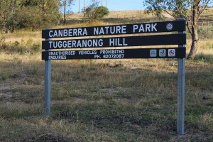
The sign for the nature park is on the left side of the entrance and this, combined with my poor map reading skills, meant we were halfway up the rural lease behind it instead of heading up Tuggeranong Hill. After actually kicking my brain into gear, we headed back across the road to the other hill – and again suffered a bit of confusion! Which way to go up? There are two very clear, very obvious paths – one which is heading straight up (the obvious and best choice!), and one which is relatively flat. Of course, we took the flat path, congratulating ourselves that we were on the right track, even though we weren’t heading straight up.
Fortunately, there are plenty of entrances to take you up the mountain. Unfortunately, we took one of the most overgrown. Despite the burrs, it was an enjoyable, steep trek through cool bushland away from the beating sun, where watching one’s footing is paramount.
Eventually, this off the beaten track path merged with the original management trail which we should have taken, and it’s a pretty glorious view – but we were far from the top.
The management trail is wide, but even with sturdy shoes it’s a little hard to get sure footing due to a layer of loose dirt-gravel over the top of the harder track. Throughout the walk – both going up and down – there were plenty of times that I went slip-sliding, so I wouldn’t confidently recommend it to anyone with lower back problems.

Not an entirely pleasant track
However, it is a great cardio work out, and there were a number of even steeper sections on the management trail which had me having to stop for breath. Eventually – even after taking two wrong tracks – we got what we came for:
a) the summit (the Garmin Heart Rate Monitor tells me it’s 866m above sea level), and

b) the views. (For those interested, you can also get up close and personal with the Tuggeranong Valley’s repeater station.)
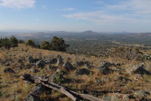
Mt Taylor and Woden in the distance

Mt Tennent on the right, and Big Monks (with the solitary tree at the top) on the left. Mt Rob Roy is out of the image but it’s to the left of Big Monks, covered in trees.
While looking at Mt Tennent I got distracted by a rather large kangaroo and snapped a couple of photos. My attention was so focussed that I almost missed what was really going on – a whole mob of them stuck their heads up! There’s something still that just ‘gets’ me when you stumble across kangaroos in the wild (probably because until they raise their heads they just look like rocks). Fortunately, our dog knew where the action was at.

The mob graciously let me take a few hundred photos before heading off on their way, and while the sun was still shining brightly at 7pm, we knew we had to make a move, too. While we missed snapping the sunset, we did get to enjoy watching the late afternoon sun light up the Tuggeranong Valley as we made our slip-slidey way back down. All in all it took a bit under an hour of walking time – but we weren’t going particularly fast.


Looking towards the top of Tuggeranong Hill

More thistles 😦

Colourful Theodore
Date: 6pm-7.30pm, Wednesday, 2 January 2013
Attendees: T1, Boyfriend and Dog
Cost: Free (except for maybe my reputation re map reading) and 423 calories
Worthwhile factor: Worthwhile
Want more? Here’s the link to our trek thanks to the GPS on the heart rate monitor (you can clearly make out the management trail with the satellite view) (it is a bit off because I forgot to take it off once we were in the car – I was having a bad day!), as well as the TAMS map
Related articles
- Battling through the thistles on Big Monks (inthetaratory.wordpress.com)
- Passionate about The Pinnacle (inthetaratory.wordpress.com)
- Top 5 Heart Rate Monitors of 2012 for Holiday Gifts by Heart Rate… (prweb.com)


You have the cutest whippet
Thanks! We think so too. He is very well behaved.
I live in Conder, and me and my Dad went up Tuggers Hill a few months ago and we went to Eaglemont Retreat, because at the top of the street a driveway heads to the firetrail and that goes to a power station and when youre 300m away from it a track goes left up the mountain. Hope to do Big Monks today 🙂
That’s cool! Good luck with Big Monks today!
My spouse and I absolutely love your blog and find the majority of your post’s to be just
what I’m looking for. can you offer guest writers to write content for yourself?
I wouldn’t mind writing a post or elaborating on many of the subjects
you write in relation to here. Again, awesome weblog!